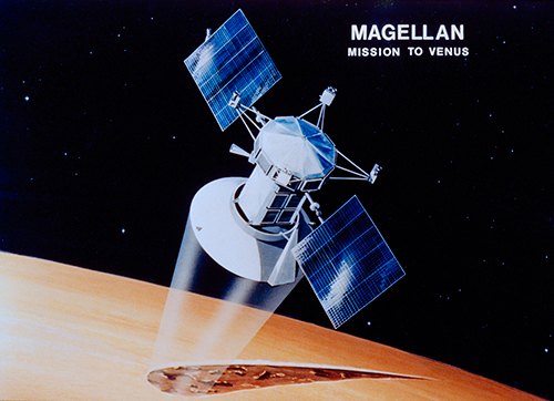
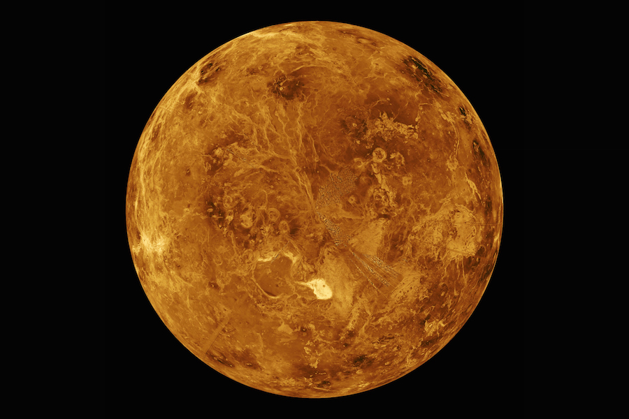
Thirty years ago today, on 10 August 1990, a tiny spacecraft arrived at Venus to begin a mission of exploration which would map over 90 percent of its cloud-obscured surface. In doing so, it would reveal tantalizing truths about a planet so similar to Earth in size, yet so different in virtually every other aspect. NASA’s Magellan mission—named for the Portuguese explorer Ferdinand Magellan, who first circumnavigated the globe in the early 16th century—had been launched aboard shuttle Atlantis in May 1989 and required 15 months to reach Venus. It went on to acquire unprecedented Synthetic Aperture Radar (SAR) imagery of craters, volcanoes, flat plains, hills, ridges and other geological features on a world long described as Earth’s “evil twin”. So impressively comprehensive were Magellan’s results that they revealed more about Venus in four short years than had been achieved in centuries of ground-based observation.
Yet Magellan had undergone a complex metamorphosis from the drawing board to launching from Pad 39B at the Kennedy Space Center (KSC) in Florida to orbiting a world so similar to Earth, yet so much a perversion of our blue-and-white paradise. Since the 1960s, it had been recognized that radar could yield crude maps of Venus’ surface, which is hidden from direct view by noxious clouds of sulphuric acid. And it was radar that helped peg the planet’s sidereal “day” at 243 Earth-days and determined its retrograde rotation.
By the end of the 1970s, plans for a Venus Orbiter Imaging Radar (VOIR) had begun in earnest. Had this mission been realized in its original concept, it would have been launched by the Space Shuttle in December 1984, reaching Venus in May 1985 and going on to map around 50 percent of the surface over six months of orbital operations. Unfortunately, VOIR’s hefty price tag caused its expected launch date to slip to no earlier than 1987 and eventually precipitated the program’s cancelation in 1982.
A stripped-down reincarnation of VOIR returned to the fore about a year later, under the new name of Venus Radar Mapper (VRM) and in 1985 it was formally named “Magellan”. In the months before the January 1986 loss of Challenger, Magellan was manifested for a shuttle launch using General Dynamics’ Centaur-G liquid-fueled booster on Mission 81I in April 1988. According to NASA’s November 1985 shuttle manifest, the two-day flight with a crew of four astronauts would have seen Magellan deployed into a low-Earth orbit at an altitude of about 184 miles (296 km).
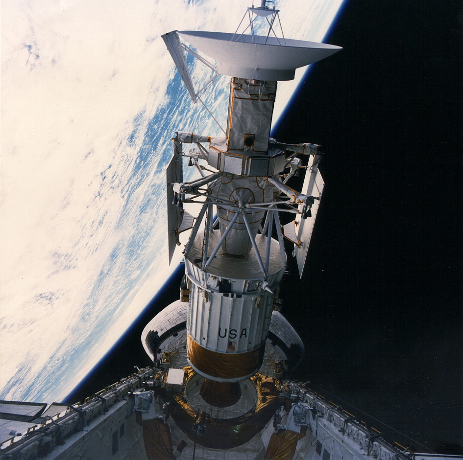
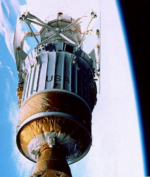
Following deployment and ignition of its Centaur-G, it would have entered a “Type I Heliocentric Orbit” and been delivered 180 degrees around the Sun to reach Venus in August 1988. Insertion of the Martin Marietta Corp.-built spacecraft—which comprised a three-axis-stabilized “bus” and twin solar array paddles, dominated by a parabolic dish-antenna for high-gain communications and radar-imaging—into Venus orbit would have been achieved by Magellan’s Star-48 solid-fueled motor.
However, as outlined in a previous AmericaSpace feature article, the hazardous Centaur-G was canceled after the Challenger tragedy and Magellan found itself baselined to fly instead atop Boeing’s solid-fueled Inertial Upper Stage (IUS). Far less powerful than the Centaur-G, the IUS demanded a significantly modified trajectory design and following the resumption of shuttle flights in the fall of 1988 the next available “launch window” to reach Venus under optimum conditions came in October 1989. However, this window quickly proved untenable, since NASA’s Jupiter-bound Galileo mission—whose own reliance upon the IUS after the demise of the Centaur-G led to a trajectory redesign which itself included a Venus flyby—was already earmarked for the October 1989 slot.
As a consequence, Magellan was manifested to fly during a four-week period from 28 April through 28 May 1989. Its “Type IV Heliocentric Orbit” would carry the spacecraft 1.5 times around the Sun in a much longer journey time of 15 months, but on the flip side the new trajectory offered advantages of lower launch energy and Venus approach velocity, as well as allowing Magellan to reach the planet over its north pole. This afforded the Magellan team the opportunity to perform mapping swathes in a north-south direction, the reverse of what had been planned for a Centaur-boosted Type I trajectory.
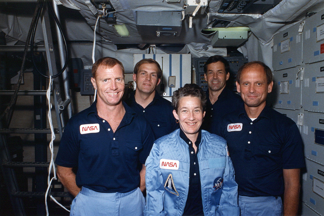
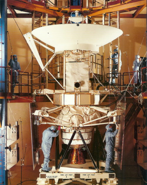
In March 1988, NASA astronauts Dave Walker, Ron Grabe, Mark Lee, Norm Thagard and Mary Cleave were assigned to STS-30, the shuttle mission which would deliver Magellan on its way. By this time, designers had passed through testing of a Structural Test Article in the spring and summer of 1987, after which Martin Marietta set to work building the spacecraft itself.
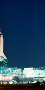
In April 1988, its Hughes-built Synthetic Aperture Radar (SAR) was delivered from Los Angeles, Calif., to Martin Marietta’s facility in Denver, Colo., where it was installed onto the Magellan “bus” for thermal vacuum tests. Six months later, the complete spacecraft arrived at KSC and commenced a lengthy process of integration of the high-gain antenna, radar module and solar arrays. By February 1989, Magellan was attached to the IUS booster and a few weeks later was moved to Pad 39B and loaded aboard shuttle Atlantis. It would be the first time the shuttle had ever launched a probe to another world.
On 28 April, the opening launch attempt was scrubbed when a hydrogen recirculation pump suffered a short circuit and stalled. The countdown was recycled for a second attempt on 4 May, but it seemed at first that this attempt, too, was snakebitten, with dreary, overcast skies and strong winds blowing across the Shuttle Landing Facility (SLF). Then came a stroke of good fortune. Fifty-nine minutes into the 64-minute window for that day, the clouds parted, the winds dissipated and mission controllers took advantage of the fortuitous break in the weather to send Atlantis on her way.
Six hours into STS-30, closely monitored by Cleave and Lee, the Magellan/IUS stack was deployed to begin its 15-month trek to Venus. In Cleave’s mind, at that instant responsibility for the payload passed from the Johnson Space Center (JSC) in Houston, Texas, to the Jet Propulsion Laboratory (JPL) in Pasadena, Calif., and she was worried that the longer it remained aboard the shuttle, the more chance existed for something to go wrong. “Get rid of this thing,” she joked to the NASA oral historian. “First day, it’s outta there!”
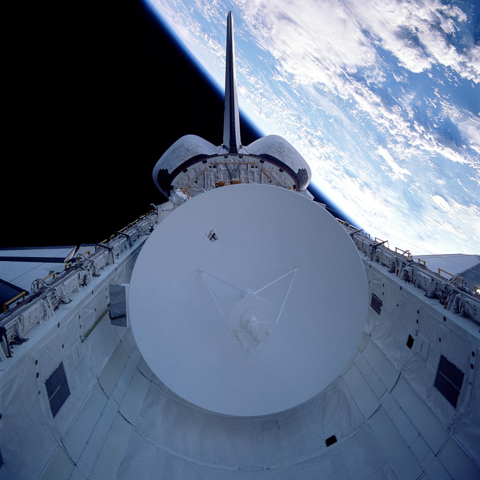
Ten minutes after leaving Atlantis, Magellan’s solar arrays deployed perfectly and a pair of IUS “burns” later that day set the spacecraft up for its transit to Venus. Over the course of the next 15 months, it utilized its hydrazine-fed thrusters to maintain its course and duly reached its destination on 10 August 1990.
All in all, the journey was unremarkable, although Magellan did suffer spurious glitches with its star scanner—which flight controllers attributed to proton bombardment during solar flares or the shedding of particles from the spacecraft itself—and persistent temperature “spikes” in its Star-48 motor. Although the latter never grew to a serious condition, managers opted to use the high-gain antenna to shield the motor and Magellan’s equipment bays from solar radiation and keep temperatures within an acceptable range.
Shortly after noon EDT on 10 August, the 15,000-pound-thrust (6,800 kg) Star-48 was commanded to fire for 83 seconds as Magellan flew “behind” Venus and contact was lost, as expected, at 12:41 p.m. EDT. It was regained 15 minutes later and a successful insertion into orbit was confirmed. Thus began a three-week In-Orbit Checkout (IOC) phase, in which the radar team adjusted their instrument parameters, ahead of the first “real” mapping cycle. The initial orbit was an elliptical one and brought Magellan as close as 183 miles (295 km) and as far as 4,823 miles (7,762 km) from Venus.
Sadly, the opening months at the planet were far from smooth. On 16 August, contact with the spacecraft was lost for almost 24 hours, and another communications dropout occurred a few days later, before the first mapping cycle of Venus’ north polar region got underway on 15 September. A month later, as Earth and Venus approached superior conjunction with the Sun, mapping was suspended for a few days, but Magellan’s woes were not yet at an end, as the spacecraft suffered a third communications loss in mid-November.
“Occasional minor data losses are expected from time to time, when the articulation and attitude-control system halts execution,” NASA reported, but stressed that “on-board systems and protective software have been improved to minimize any data losses”. A few days later, ground computers were blamed when Magellan placed itself into safe mode and four mapping orbits were lost, but by late November 1990 the mission seemed to be moving steadily back on track.
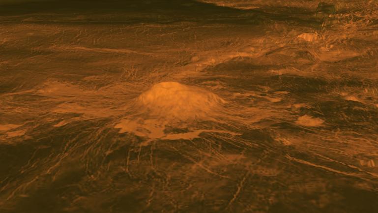
In fact, despite these early teething troubles, mission managers were confident that Magellan could achieve its target of 70-percent coverage of Venus by the end of its first 243-day mapping cycle. By early December, 32.9 percent of the planet had been imaged, including the large continental area of Ishtar Terra and the 7-mile-high (11.2 km) mountain, Maxwell Montes. Mountainous slopes dusted with a metallic substance, though to be iron pyrite, were observed, together with volcanic dome-like features and vast, horseshoe-shaped geological formations. This success was tempered by the several orbits of data loss and a high error rate from one of Magellan’s two radar data tape recorders.
Success improved gradually in 1991 and efforts to better protect the spacecraft from the intense solar heat by shortening its radar-mapping passes and periodically turning the solar arrays by 90 degrees to reduce incident sunlight levels were successful. In April, a “Two Hide” strategy—which placed part of the spacecraft in the shade of the high-gain antenna twice per orbit, to keep the electronics cool—was implemented.
Venus begrudgingly yielded more of its secrets, offering insights into the nature of its surface and atmosphere and evidence of ongoing volcanism and possible tectonic activity. Magellan’s data also confirmed that the number and relative size of impact craters was broadly in-line with pre-flight predictions, suggesting that the dense atmosphere had acted as a shield against significant meteoroid bombardment.
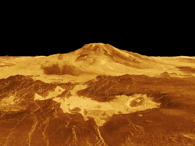
Turbulent surface winds and an ancient atmosphere, perhaps 400-800 million years old at least, were also hinted at by the spacecraft. Magellan revealed that Venus was venting internal heat, through giant oval hot spots known as “coronae”, vast circular structures called “arachnoids” and petal-shaped lava flows, and its measurements were employed to examine dust movements and make inferences about wind speeds in the lower atmosphere.
By the start of its second cycle in May 1991, the spacecraft had mapped 84 percent of the surface, which climbed to 90 percent by the end of July, despite periodic data dropouts and occasional losses of contact. Magellan observed a 4,200-mile-long (6,800 km) channel—longer than the River Nile—and revealed that 85 percent of Venus is covered by volcanic rocks, most of which represent lava flows which formed the planet’s great plains.
In September 1992, having imaged around 99 percent of the surface, Magellan’s orbit was lowered from 186 miles (300 km) to 111 miles (180 km) for global gravity mapping. And from May-August 1993, the spacecraft pioneered the technique of “aerobraking”, in which it dipped into Venus’ upper atmosphere and used the effects of drag to reduce its orbit from an elliptical to a circular one for greater scientific yield. Surface observations from the elliptical orbit had been blurred at high altitude and aerobraking refined Magellan’s orbit to a period roughly equivalent to low-Earth-orbiting shuttle missions.
Yet the end of the mission drew inexorably closer. In early 1994, additional funding was granted to complete gravity mapping through September, which revealed little change on the surface in 500 million years or more. And in September, a week-long “windmill” experiment saw controllers turn the spacecraft’s solar arrays in opposite directions to carefully measure molecular pressures in the upper atmosphere. A few weeks later, in early October, five orbit-trim maneuvers lowered the close point of Magellan’s orbit to 86 miles (139 km) for more aerodynamic data-collection. In spite of increased temperatures on its solar arrays, the hardy spacecraft remained stable until the very end.
But the end was indeed close. Eventually, main spacecraft bus voltages reached 24.7 volts and, despite predictions that contact would be lost if it dipped below 24 volts, it was not until 20.4 volts that power starvation finally drove Magellan’s battery offline. Contact was officially lost at 6:02 a.m. EDT on 12 October 1994, bringing to an end one of the most successful missions ever undertaken in space science.
Ninety-eight percent of the surface was mapped at resolutions of better than 1,000 feet (300 meters) and Magellan’s gravity mapping campaign had covered 95 percent of Venus. “The data which streamed back from Magellan’s radar images, its atmospheric studies and its gravity data acquisition maneuvers,” explained JPL project manager Douglas Griffith, “have built a vast database of new knowledge about Venus and the formation of the Solar System that will be studied by scientists for decades to come.”
As the radio subsystem (Telecomm) technician/Engineer, I was a proud member of the Magellan team from the time we started building it to the last day of the mission. In cost cutting measures, layoffs occurred over the last couple of years or so. I lasted until somewhere around the last year.
I was allowed to come out to the control room on that last night. I remember watching the battery voltage drop over the last few orbits. Finally, data was lost. On the final orbit we saw, all that could be seen by the DSN (Deep Space network) was possible carrier. But even what they saw was so low level that they couldn’t be sure. And then it was gone. Six or seven of us decided to go have breakfast (It was by then around 6 A.M. in Denver,) so we left. We secured our equipment and, as they say, the last one out turned off the lights. That was a sad, sad morning.
Magellan and it’s team members were the highlight of my career. I truly was in the right place at the right time to be assigned to the project. I was proud to be a part of it all.
It’s a great article about an amazing mission, to my favourite planet of them all! Thanks for your comment, too, Walt – must have been incredible to work there at that time.
It would be very interesting to create a long-duration rover to give us a comparative look at the surface of Venus to compare with Mars. I would imagine the technical challenges would be monumental.